


Climate Software Lab (CSL), the climate technology arm of GPS Renewables, a full-stack clean fuels company, has launched a landslide risk assessment model that can map landslide risks for susceptible areas in the Indian subcontinent, covering nearly 40 lakh people. This tool is free open-source software that uses a host of local factors, such as slope, local relief, forest loss, and tree canopy height, to map an area's susceptibility.
Landslide risk in India
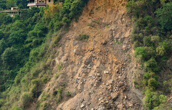
Landslides continue to pose a significant threat to large parts of India, including areas like the Himalayas, North-Eastern hill ranges, Western Ghats, Nilgiris, Eastern Ghats, and Vindhyas. A report by the Indian Academy of Sciences indicates that annually, about 500 lives are lost due to landslides, and the damage to property is estimated to be about Rs 300 crore. Unlike other natural disasters such as floods and cyclones, it is difficult to predict when and where landslides will occur; rain is often a trigger event for a landslide. Hence, the task before policy planners, scientists, and administrators is to use the latest technology for mitigation strategies. CSL's Landslide Susceptibility Model was developed with the aim of addressing the above need.
A tech-powered landslide susceptibility assessment system
Developed by a team of AI experts and scientists at GPS' Climate Software Lab, the tool uses data on local conditions, including tree height and its rate of change, soil clay content, and human modification, as well as the Geological Survey of India's (GSI) dataset, which contains information about past landslide locations. Further, CSL's tool customises NASA's existing Landslide Hazard Assessment for Situational Awareness (LHASA) model to suit Indian conditions and provide better spatial resolution to enable policymakers and administrators to plan local interventions for vulnerable populations and important assets.
Nipun OS, Chief Sustainability Officer, GPS Renewables, said, "With our new open source tool, our aim is to address a critical gap that currently exists in landslide risk assessment models. During our research, we found that many states in India depend on old and low-resolution susceptibility maps to draw up landslide prediction models. CSL's tool addresses this gap by providing high-quality risk visualisations that would enable policymakers to develop local-level disaster response strategies. The tool is free and open-access, making climate-related data more accessible to more people."
Mainak Chakraborty, CEO and Co-Founder, GPS Renewables, said, "Climate change poses an existential threat, and it needs collective action. We firmly believe that technology can play a crucial role in mitigating the risks of climate change, and this is precisely why we established the Climate Software Lab."